The layout
Fushimi Inari map: what is where on the mountain
Fushimi Inari is not a building with rooms, it is a mountain with a path up it, and the single most useful thing to know before you arrive is the order of what you will meet. There are four decision points between the entrance and the summit, and knowing where they are is the difference between a twenty-minute visit and a three-hour one you chose on purpose.
Quick answer
Fushimi Inari Taisha runs uphill from Inari station: the Romon gate, the main hall, then Senbon Torii, then the Okusha shrine at the top of the dense tunnel. Above that the path climbs to the Yotsutsuji crossroads, roughly halfway, 30 to 45 minutes from the entrance and the only viewpoint over Kyoto. From Yotsutsuji a loop of about four kilometres circles the summit of Mount Inari, 233 metres, and takes two to three hours in total.
The map in numbers
- Entrance to main hall
- ~5 minflat, past the Romon gate
- Main hall to Senbon Torii
- ~5 minthe tunnels start behind it
- Length of Senbon Torii
- ~100 mtwo parallel tunnels, over 1,000 gates
- To the Okusha
- ~15 mintop of the dense stretch, weighing stones
- To Yotsutsuji
- 30–45 minhalfway, and the view over the city
- Full loop
- ~4 km2–3 hours from the entrance and back
- Summit of Mount Inari
- 233 mno view — the trees close over it
- Path surface
- Stone stepsnot a graded trail
- Signage
- Japanese and Englishand hard to get lost on
- Cost of any of it
- Freethe whole mountain, at any hour
Bottom to top
What is where at Fushimi Inari, in order
One path, seven landmarks, and two sensible places to turn around.
Everything is on one line, and you meet it in this sequence walking up from the station.
The approach street. Between Inari station and the shrine, lined with food stalls. Inari-zushi is the local dish. This is where you buy water for the climb, because the prices on the mountain rise with the altitude.
The Romon gate. A vermilion gate the height of a house, donated in 1589 and rebuilt since. Two stone foxes flank it; look at what each is holding.
The main hall. Rebuilt in 1499. This is where people pray and where the coach groups stop. The amulet counter is beside it, open roughly nine to five.
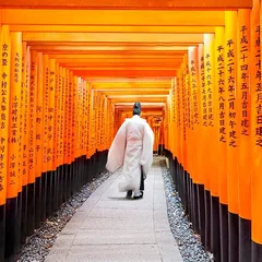
Senbon Torii. Behind the main hall, the path splits into two parallel tunnels of gates set a step apart. A hundred metres. Right-hand tunnel going up, left coming down.
The Okusha. At the top of the tunnels, a small shrine with the omokaru-ishi weighing stones beside it. Most visitors turn around here without realising there is anything above.
Yotsutsuji. Thirty to forty-five minutes of steps above the Okusha, a crossroads where the trees open and Kyoto appears below. Teahouses, benches, and the honest place to stop.
The summit loop. From Yotsutsuji the path circles the top of Mount Inari through cedar forest past hundreds of small stone altars. There is no view from the summit itself. The reward is that you will barely see anyone.
Reading the mountain
Six things the signs do not make obvious
The layout has a logic, and it is not written down anywhere on site.
- The crowd density halves every ten minutes above the Okusha
This is the single most useful fact about the map. Ten minutes of climbing past the point where everybody stops and you have the same gates to yourself.
- The two tunnels of Senbon Torii rejoin
They are not different routes. Right going up, left coming down, and you end in the same place either way.
- Yotsutsuji is the only real viewpoint
The summit has none. If a view over Kyoto is what you climbed for, Yotsutsuji is the destination and going higher adds forest rather than scenery.
- The loop can be walked either way
From Yotsutsuji the circuit goes clockwise or anticlockwise and rejoins itself. Neither is better; both are about the same length.
- There are side paths down into the neighbourhood
Several, and they are not obvious. Unless you know where you are going, come back the way you went up.
- The whole thing is stone steps
Not a graded trail and not paved. This matters more than the distance, especially coming down in the wet.
If the mountain is the part you want, no coach tour will give it to you — they allow sixty to ninety minutes and stop at the Okusha.
The hike up Mount Inari, in full→Where it is
Where is Fushimi Inari Taisha on a map of Kyoto?
Southern Kyoto, on the Nara railway line, and nowhere near Arashiyama.
In the south of the city, in the Fushimi ward, at 68 Fukakusa Yabunouchicho. That puts it about five kilometres from Kyoto Station and well away from the eastern hills where Kiyomizu-dera and Gion are, and a long way indeed from Arashiyama, which is on the western edge of the city about an hour across.
The practical consequence is worth planning around. Fushimi Inari pairs naturally with Tofukuji, one JR stop closer and a twenty-minute walk, and with Nara, which is further down the same railway line. It pairs badly with Arashiyama, which is why every tour that does both in one day is selling you the transport rather than the sights.
Mount Inari itself is 233 metres and sits directly behind the shrine buildings. The shrine occupies the foot of it and the paths occupy the rest, which is the whole reason the site is as large as it is: you are not walking around a shrine, you are walking up a hill that the shrine covers.
Every trip, current fare
Tours, and how much of the map they cover
Twelve tours, cheapest first. All of them reach the main hall and Senbon Torii; none of them climb to Yotsutsuji, which is why the length column is really about the rest of the day.
| Tour | Length | Price | Other stops | Cost per hour | Rating |
|---|---|---|---|---|---|
| Nara, Fushimi Inari & Arashiyama Bus TourThree sights, one coach, the lowest price here | 9–10 h | $50 | Nara, Arashiyama | $5.26 | 4.8 · 3,168 |
| Early Morning Fushimi Inari & ArashiyamaThe only one that beats the crowd to the gates | 6 h | $62 | Arashiyama, Kinkakuji | $10.33 | 4.9 · 1,597 |
| Kyoto by Bus: Nijo, Bamboo Grove & Fushimi InariNijo Castle and the bamboo, in English or Spanish | 11 h | $62 | Nijo, bamboo grove | $5.64 | 4.7 · 761 |
| Crowd-Free Kyoto: Fushimi Inari, Nijo & KinkakujiFive hours, and built around the early start | 5 h | $67 | Nijo, Kinkakuji | $13.40 | 4.5 · 23 |
| Private Tour: Fushimi Inari & BambooA licensed guide for your group alone | 3.5–6 h | $68 | Arashiyama bamboo | $14.32 | 4.9 · 6 |
| Kyoto Bus Tour: Fushimi, Kiyomizu, Kinkakuji & ArashiyamaThe five names everybody knows, in one day | 10 h | $81 | Kiyomizu, Kinkakuji, Arashiyama | $8.10 | 5.0 · 72 |
| Kyoto Full-Course: 10 Must-SeesTen stops for a single day in Kyoto | 9.5 h | $92 | Ten in total | $9.68 | 4.9 · 194 |
| Fushimi Inari, Kinkakuji & Bamboo GroveSix sights with every entry ticket included | 8.5–9 h | $93 | Kiyomizu, Kinkakuji, bamboo | $10.63 | 4.8 · 5,297 |
| Full-Day City Highlights Bike TourThe whole city by bicycle, lunch included | 8 h | $171 | Gion, Kiyomizu, bamboo | $21.38 | 4.9 · 56 |
| Customized Private Tour with Licensed GuideA licensed guide, and the route is yours | 4–8 h | $201 | Your choice | $33.50 | 4.8 · 523 |
| Private Highlights Tour with Guide and VehicleA car and driver for the whole day | Full day | $295 | Your choice | $36.88 | 4.9 · 121 |
| Private Highlights Tour with Guide and VehicleA driver-guide, and you write the itinerary | Full day | $415 | Your choice | $51.88 | 4.6 · 471 |
Common questions
The Fushimi Inari map, answered
How big is Fushimi Inari Taisha?
The shrine buildings occupy a small area at the foot of the hill, but the site includes the whole of Mount Inari — 233 metres high, with a path loop of about four kilometres and roughly ten thousand gates along it.
Where is Senbon Torii on the map?
Directly behind the main hall, about ten minutes’ walk from the entrance. It is the first dense stretch of gates you meet and it runs for roughly a hundred metres.
What is Yotsutsuji?
A crossroads roughly halfway up Mount Inari, thirty to forty-five minutes of stone steps from the entrance. It is the only place on the mountain where the trees open onto a view of Kyoto, and it is where most people sensibly turn around.
Is there a view from the top of Mount Inari?
No. The summit is wooded and closed in. The view is at Yotsutsuji, halfway up. People who climb to the summit do it for the emptiness and the small altars, not the scenery.
How long is the full loop at Fushimi Inari?
About four kilometres and two to three hours from the entrance and back, on stone steps rather than a graded path.
Where is Fushimi Inari in Kyoto?
In the Fushimi ward in the south of the city, about five kilometres from Kyoto Station and two stops down the JR Nara Line. It is close to Tofukuji and a long way from Arashiyama.
Do you need a map at Fushimi Inari?
Not really. The main route is one path with signs in Japanese and English at every junction, and it is hard to get lost on. Side paths down into the surrounding neighbourhood are less obvious, so if you are unsure, return the way you came.
Go deeper
More on Fushimi Inari Taisha
Fushimi Inari Shrine
What it is, what it costs, and the hour to arrive.
The gatesTorii gates Kyoto
Where the ten thousand gates are, and how to photograph them empty.
By colourThe red gates of Kyoto
What they are called, and the three other red buildings people mean.
ToursWhich tour is worth it
Six compared, and the two situations where a tour earns its price.
CostTickets and entrance fee
There are none. What a visit actually costs, and why other sights charge.
HoursWhen it is open
It never closes. Hour by hour, and when the crowd arrives.